- Severe weather leads to fallen trees, car crashes and flooding around the Triangle
- New video shows vehicles being swept away in historic, deadly flash floods in SA on June 12
- $40 million to go to underserved SC counties for Hurricane Helene recovery. Here's what you need to know.
- Family honors Air Force veteran Derwin Anderson Jr. after he died in June flash floods
- City of Wilmington addresses flooding on New Centre Drive
Where flooding is happening: List of rivers and streams that are out of their banks, as well as those that are close
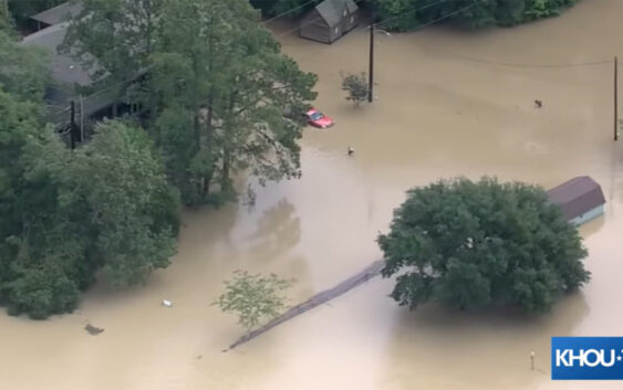
HOUSTON — We’re tracking high water all across the Houston area following days of heavy rain. And with more rain in the forecast, things are expected to get worse.
The Harris County Flood Control District is keeping tabs on rivers and streams that are out of their banks and those that are nearing it. Here is what they posted shortly after 11:30 a.m. Saturday.
You can also check the Harris County Flood Control map anytime. There are explainers on how to read it and what the different monitors mean. We have links here.
If you are in an area that’s flooded, you can get a free ride to safety. Just call 311.
FREE transportation services for evacuation are now available!
If you or someone you know requires transportation for evacuation, please contact 311 immediately. pic.twitter.com/syYCM9pKbl
— Houston OEM (@HoustonOEM) May 4, 2024