- Houston Cougars take on A&M Aggies in charity exhibition game supporting Hurricane Beryl relief
- Hurricane Helene donations delivered to Avery County for Share the Warmth campaign
- Old Crow Medicine Show founder talks music, hurricane relief and this weekend's big benefit show
- IV fluid shortage caused by hurricane to last for months
- 'It financially annihilated us': Pregnant mother displaced for 2nd time after western NC floods
Why the end of El Niño could spell an active hurricane season
The shift in global weather patterns is expected to play a big role in active hurricane season.
CHARLOTTE, N.C. — El Niño, a climate pattern with huge impacts on weather patterns worldwide, has officially ended. This sets the stage for the anticipated arrival of the La Niña pattern later this year.
The El Niño pattern had been in place since last year, according to the National Oceanic and Atmospheric Administration’s Climate Prediction Center. On Thursday, NOAA updated its guidance to say the El Niño pattern was no longer present.
Meteorologists continue to anticipate the arrival of La Niña before the end of the year. The anticipated presence of La Niña conditions during this Atlantic hurricane season is one of the reason many meteorologist are expecting a more active hurricane season than average.

El Niño and La Niña are opposites with a transitional natural phase in between the swinging pattern.
RAISE YOUR WEATHER IQ: This is likely to influence an above-average hurricane season
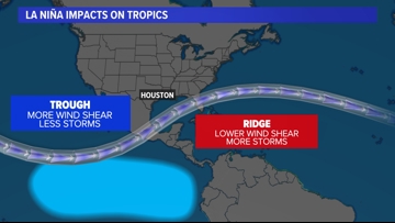
What is a La Niña pattern
The temperature difference in the Pacific Ocean has a direct impact in the Atlantic Ocean.
During La Niña conditions, there is more rising air in the Caribbean and around the Gulf of Mexico. This means more thunderstorms and tropical potential in the Atlantic Ocean basin.
This flow also supports the trade winds coming from the African coastline, where many tropical waves form as they move over the Atlantic. This is the traditional start to many hurricanes.
Wind shear, which is the changing of wind direction or speed at different levels of the atmosphere, hinders hurricane development because hurricanes weaken when they are titled by the differing winds. However during La Niña, there is less wind shear which gives the advantage to tropical development.
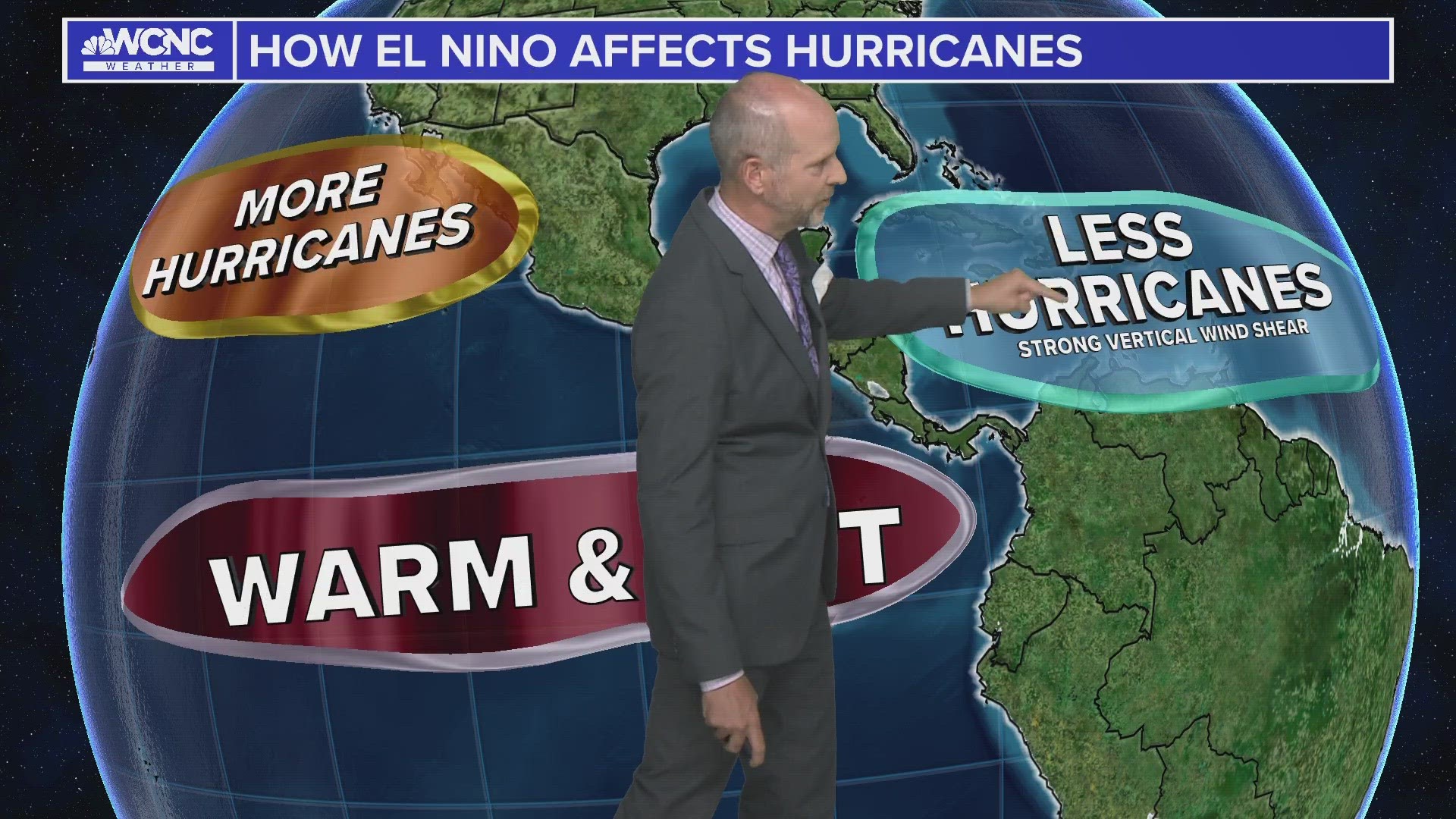
What is an El Niño pattern
During an active El Niño pattern, the temperature of surface waters in the tropical Pacific Ocean becomes warmer than average. During January, those conditions continued across the Pacific waters, according to NOAA. However, a greater examination of both ocean and atmospheric conditions reflected a weakening El Niño pattern, according to NOAA.
There is a historical tendency for La Niña to follow strong El Niño events, and 2024 is expected to be no exception.
El Niño usually happens every two-to-seven years and can last for several months or as long as years. Its prevalence in 2023 and into the start of 2024 has been observed in the current weather pattern.
RAISE YOUR WEATHER IQ: What is El Nino, and why should we care?
Recent snowless winters in Charlotte can be directly attributed to three years of the La Niña pattern, according to WCNC Charlotte Chief Meteorologist Brad Panovich who noted such conditions in his annual winter weather outlook in November. El Niño brings wetter and warmer weather to Carolina winters.
Despite the disappointment of Carolina snow lovers, El Niño conditions have helped resolve a months-long drought in the Carolinas.
More Videos
For the 2023 hurricane season, El Niño likely limited hurricane development in the Atlantic Ocean basin. The opposite could be true during a strong La Niña pattern, which promotes hurricane development in the Atlantic.
For now, meteorologists will continue to track ocean and atmospheric conditions to track the ongoing status of El Niño.
WCNC Charlotte’s Weather IQ YouTube channel gives detailed explainers from the WCNC Cweaharlotte meteorologists to help you learn and understand weather, climate and science. Watch previous stories where you can raise your Weather IQ in the YouTube playlist below and subscribe to get updated when new videos are uploaded.