- EF-1 tornadoes ripped through Cypress, Waller County areas with winds at more than 100 mph, NWS reports
- Houston-area storm damage updates: Clean up continues after NWS says two EF-1 tornadoes and powerful derecho ripped through SE Texas
- Low risk of damaging winds, hail from Saturday storms
- EF 1 tornadoes ripped through Cypress, Waller County areas at more than 100 mph, NWS reports
- Caddo Mounds State Historic Site to celebrate new visitor center, traditional grass house after 2019 tornado
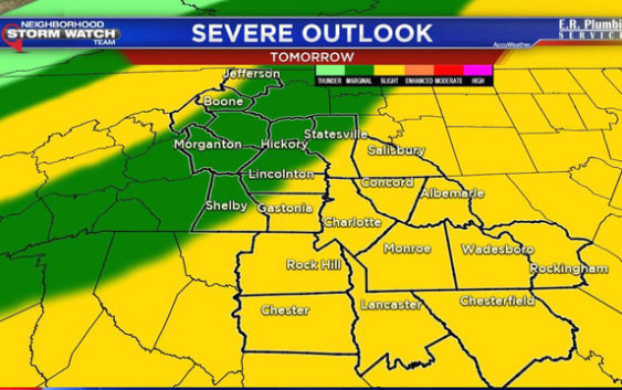
Counties under risk of damaging winds, tornado

Monday will start cloudy and damp with a few spots of mist and drizzle. The rest of the day will feature mostly cloudy skies and seasonal highs around 66.
A cold front will swing through during the midday hours on Tuesday and possibly fire up some strong to severe storms.
Main concerns will be damaging straight line winds and an isolated tornado risk.
The storms will clear quickly leaving plenty of sunshine in the forecast for Tuesday evening into Wednesday.
Today: Mostly cloudy with a high of 66.
Tomorrow: Cloudy with a 70% chance for strong to severe storms. High of 74.
Wednesday: Partly sunny and 69.
Another batch of rain will move in on Friday but clear out just in time for the rest of the weekend. Saturday and Sunday looks GREAT with sunny skies and highs in the 50s.
The rest of the day today will be damp & cloudy with a high of 66. As a cold front swings through tomorrow there will be a chance for strong to severe storms between the hours of 11-4 everywhere under the yellow shading. Main concerns are straight line winds & isolated tornadoes pic.twitter.com/UcNGgSWqKa
— Nick Kosir (@FOX46Nick) November 5, 2018