- SkateWorld roller skating rink reopening over a year after tornado ripped through Deer Park
- Tornado Watch canceled for all counties except Milam
- Live radar, updates: Tornado Watch issued for parts of the KVUE area
- Tornado watch issued for Williamson County until midnight Thursday
- Severe weather: The impact flash flooding has on Central Texas
Dramatic photos of severe flooding and storm damage across Houston area shared by readers
-
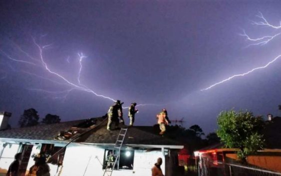
“HFD responding to a house fire earlier on Rebel Road,” tweeted the Houston Fire Department.
“HFD responding to a house fire earlier on Rebel Road,” tweeted the Houston Fire Department.
Photo: @HoustonFire
“HFD responding to a house fire earlier on Rebel Road,” tweeted the Houston Fire Department.
“HFD responding to a house fire earlier on Rebel Road,” tweeted the Houston Fire Department.
Photo: @HoustonFire
Widespread rainfall between 1 and 7 inches and golf-ball sized hail were reported in the Houston area overnight, Chron.com reported.
Incidents involving flooded streets, stalled cars and damage from fallen trees and lightning have been reported.
The Houston TranStar map has identified 22 high water locations to avoid, including Interstate 45 northbound at Interstate 10 East and Interstate 45 northbound at Memorial.
Stay in the know as more rain is expected to hit the Houston area Friday and Saturday.
For the complete list of high water locations and a weather update, see Chron.com’s report: Multiple high water locations reported as storms drench Houston area
Get an updated list of school closings here: Storms prompt school, event cancellations around Houston
>>> See above for a look at the severe flooding across Houston …
Marcy de Luna is a digital reporter. You can follow her on Twitter @MarcydeLuna and Facebook @MarcydeLuna. Read her stories on our breaking news site, Chron.com, and on our subscriber site, HoustonChronicle.com. | Marcy.deLuna@chron.com | Text CHRON to 77453 to receive breaking news alerts by text message