- Dozens injured and at least five confirmed dead — including children — after reported tornado Saturday night, North Texas sheriff says
- Carolina Hurricanes General Manager Resigns
- North Carolina to provide state-relief funds for Gaston Co. storm damage victims
- More severe weather forecast in Midwest as Iowa residents clean up tornado damage
- Preparing food for hurricane season: Essential food and water strategies for emergencies
Brad: “Massive storm system” brings damaging winds early Monday
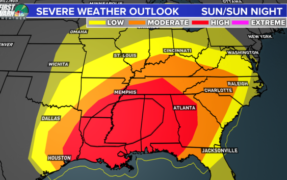
CHARLOTTE, N.C. — A “massive storm system” is headed to the Carolinas and across the Southeast Sunday night into Monday morning, said WCNC Charlotte Chief Meteorologist Brad Panovich.
The severe weather outbreak, which will begin in portions of Texas Saturday moving moving east on Sunday and Monday, brings a high chance of damaging winds. The storm system also contains a risk of tornadoes and flooding.
“This time of year, you have dynamic storms in April,” Panovich explained. “You have the crossover of the strong winds associated with the winter time jet streams – and the springtime heat and humidity. When those two meet up, we get massive severe weather outbreaks.”
When you wake up Sunday morning, scattered rain will already have arrived in Charlotte and across the Carolinas. Rain will contain throughout the day on-and-off with some breaks.
During the day on Easter, the threat of damaging severe weather remains to our west: in Louisiana, Mississippi, Alabama and Georgia.
RELATED: Statesville man fatally struck by a tree
As we head through the day Sunday, winds will begin to increase.
By 1 a.m. Monday morning, the first line of heavy rain and winds are expected across the western North Carolina mountains, including places like Asheville, Boone, and Blowing Rock. Winds could exceed 50 mph.
“The wind energy is crazy with this system,” Panovich said. “It goes bonkers by Monday morning.”
By 4 a.m., the heavy rain and wind move across the Piedmont and into Charlotte.
“One thing I can tell you for sure with my highest confidence: we’re going to see widespread damaging winds,” Panovich explained.
“Tornadoes are like pins. They’re tiny on a map. Compared to the giant swath of damaging winds,” Panovich said. “It’s like a paint roller [across the region].”
Winds speeds could climb into the 50 or 60 mph range. If the wind were to gust at 74 mph or stronger, it would be as strong as a category one hurricane.
The chance of severe weather only begins to move out and decrease after 9 a.m. Monday.
The exact timing of the severe weather could change as the forecast continues to develop. Timing changes could trend the chances of severe weather up or down.
Either way, now is the time to prepare. Charge your phone. Find your flashlights. And make sure you have multiple ways to receive severe weather bulletins, including options like a NOAA Weather Radio or the WCNC app that will make sound and alert you while you’re sleeping.
Pro tip: Consider NOT putting your phone on Do Not Disturb when you go to sleep Sunday. This way you will hear calls or apps alerting you to any potential severe weather.
More news:
Churches offering virtual fellowship for Easter
List: Charlotte area churches streaming Easter Sunday service
False negatives risks coronavirus spread
Charlotte lights up purple for healthcare workers: Real-time updates Friday, April 10
5 Charlotte Wells Fargo employees test positive for COVID-19