- Tropics could help bring beneficial rainfall - but also minor flooding - to Central Texas
- ReadyBrunswick Hurricane Expo held in Bolivia
- Why the end of El Niño could spell an active hurricane season
- Flooding in South Florida grounds flights, strands Saint Augustine student and others
- After rare flash flood emergency, Florida prepares for more heavy rainfall in coming days
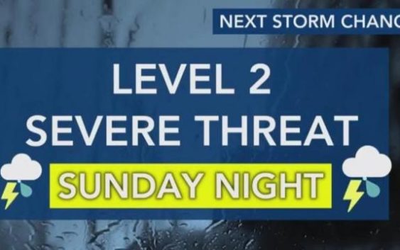
Easter Sunday brings rain, overnight severe storms with damaging winds, isolated tornadoes
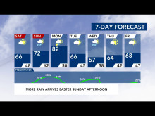
On the Saturday before Easter, the Triangle woke up to near-freezing temperatures and a frost advisory.
However, by Easter Sunday the temperatures are forecast to rise back into the 70s, bringing rain and a level 2 risk for severe weather–including damaging winds, hail and even isolated tornadoes.
“This is the time to download that WRAL Weather app and track those storms with us as they move through,” said WRAL meteorologist Peta Sheerwood.
Saturday afternoon will warm up a bit, with sunny conditions and temperatures in the 60s, making for beautiful weather for outdoor activities.
Sunday brings a high of 71, but the scattered rain chances will increase as the day goes, up to 50 percent by the mid-afternoon.
“If you’re thinking about getting the kids out in the backyard for an Easter egg hunt, do it Saturday or early on Sunday,” said Sheerwood.
The best chance for severe weather will start around 3 a.m. Monday with the bulk of the storms hitting the Triangle by 7 a.m.
These storms carry the potential for damaging winds and hail–even an isolated tornado can’t be ruled out.
“We’re going to watch those wind speeds get up to 60 or 70mph,” said Sheerwood.

Monday’s high could reach into the 80s, but the temperatures will cool through out the week, dropping into the 60s on Tuesday and 50s on Wednesday.