- Rock Hill storm damage costs are 'somewhere around $5 million.' That number doesn't include damage to personal property
- Rock Hill storm damage costs are 'somewhere around $5 million.' That number doesn't include damage to personal property
- ‘Somewhere around $5 million’ | Rock Hill officials see major storm damage costs
- The deadliest tornadoes to ever hit Austin
- Whiteville resident recalls events from Tuesday nights tornado
Tropics: Disturbance in the Caribbean likely to become Tropical Storm Fred today
Tropical Storm Warnings are in effect for Puerto Rico, the U.S. Virgin Islands, and a portion of the Dominican Republic.
JACKSONVILLE, Fla. — We’ll be keeping an eye on Invest 94L as it heads west across the basin. It’s always a good idea to check in often during this time of year. The Atlantic hurricane season peaks, according to climatology, on September 10.
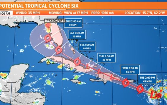
POTENTIAL TROPICAL CYCLONE SIX: This is the one to watch for the U.S. Southeast and the First Coast as long-range models are showing impacts by later this weekend and early next week. What those impacts are, if any, are still to be fine-tuned as this system develops. As of now, the Jacksonville area should plan for increased rain chances by the weekend.
As of Monday morning, showers and thunderstorms have become more concentrated in association with Invest 94L, or a low-pressure system located about 150 miles east of Barbados. With warm sea surface temperatures and relatively low wind shear, gradual development is expected to continue. A tropical depression is likely to form later today or tonight while the low moves west-northwestward at 10 to 15 mph. The disturbance is forecast to reach portions of the Lesser Antilles tonight, then move near the Virgin Islands and Puerto Rico on Tuesday, and be near Hispaniola around the middle of this week. Tropical storm watches or warnings could be required today with shorter-than-normal lead times for portions of the Lesser Antilles, the Virgin Islands, and Puerto Rico. In addition, heavy rains and flooding are likely for the Leeward Islands, Virgin Islands, and Puerto Rico.
Looking deeper into the season, the Climate Prediction Center has issued a La Niña Watch with La Niña potentially emerging from September through November. La Niña can help make atmospheric conditions more conducive for tropical cyclones to form the Atlantic, and less conducive in the Eastern Pacific. If 2021 is any indicator so far of what lies ahead this season, it could continue to be an active year. As of the beginning of July, there have been five named storms breaking the previous record set just last year. In August, the Climate Prediction Center will issue an updated hurricane outlook.
Hurricane season is here and it’s time to be prepared if you aren’t already. Make sure you have had conversations with your loved ones about what you would do if a storm were to threaten.
This year, NOAA released the new seasonal averages for the Atlantic basin. According to the 30-year data from 1991 to 2020, the new averages include 14 named storms, 7 hurricanes, and 3 major hurricanes. The previous Atlantic storm averages, based on the period from 1981 to 2010, were 12 named storms, 6 hurricanes, and 3 major hurricanes. The averages from 1951-1980 , were 11 named storms, 5 hurricanes, and 1 major.
Hurricane safety and preparedness are critically important before the season begins on June 1. NOAA’s National Weather Service provides resources to prepare for hurricane hazards and real-time updates about active weather systems from the National Hurricane Center at www.hurricanes.gov.
The Atlantic hurricane season officially runs from June 1 to November 30.
Download the First Coast News app and sign up for severe weather alerts