- California wildfire burns out of control but firefighters could get a break when winds diminish
- 'Flooding is our number one natural disaster' | Breaking down the voter-approved Harris County Flood Control District tax rate hike
- Powerful Category 3 Hurricane Rafael knocks out power in Cuba as it heads to the island
- NC Forest Service warns of increased wildfire risk in western part of state after Helene
- First responders searched for hours after being told two people were swept away in flash flood
Hail, tornadoes a potential in Houston-area storms Thursday

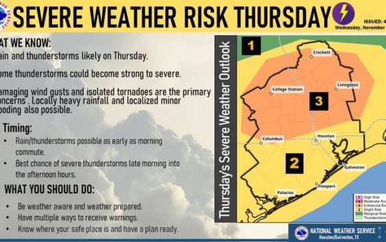
Severe storms are expected to move through the Houston-area Thursday, accompanied by high winds, isolated tornadoes and hail in areas north of Houston.
The greatest area of concern for severe weather is between Houston, College Station and Columbus, with increased rainfall closer to the coast, according to the National Weather Service. The area could see one to three inches of rain with increased humidity blanketing much of Houston throughout the day.
Officials and weather experts are encouraging Houstonians to stay weather aware when driving on Houston roadways Thursday. A traffic map of potentially flooded roadways can be found on the Houston TranStar website.
Those potential rainstorms likely won’t move into Houston until late morning or early afternoon.
“What we do anticipate is that we will have additional development as the day progresses,” Joshua Lichter, a senior meteorologist with the National Weather Service said Thursday morning.
“The best chances will probably be coming this afternoon into maybe early this evening,” he said. “And that is when in the late morning through early afternoon hours when the greatest risk for anything strong to severe could develop.”
The storm system will move East through the Houston-area, and the potentially severe storms could move on by late afternoon or evening, according to Space City Weather.
“We can’t rule out the threat of locally heavy rainfall which could lead to some flooding,” Lichter said. “Localized flooding in the area. We are saying around one to three inches are going to be found in the higher amounts. Some of those numbers could be even higher if training or repeated storms happen.”