- ReadyBrunswick Hurricane Expo held in Bolivia
- Why the end of El Niño could spell an active hurricane season
- Flooding in South Florida grounds flights, strands Saint Augustine student and others
- After rare flash flood emergency, Florida prepares for more heavy rainfall in coming days
- Centers flooding state leaders with calls pushing for child care funding
This is likely to influence an above-average hurricane season
Historically, the La Niña phase of the ENSO cycle has produced the most active seasons on record. Here is why, and which historic years were driven by “the girl.”
CHARLOTTE, N.C. — Some of the most active Atlantic hurricane seasons in history all occurred during La Niña conditions.
Let’s raise our Weather IQ about the climate pattern that translate to “the girl” and how this part of the ENSO cycle affects the number of hurricanes.
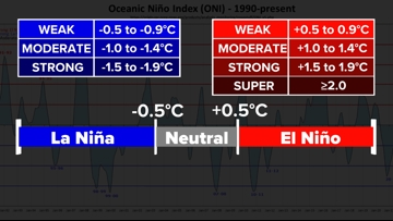
What is the Enso Cycle?
The El Nino Southern Oscillation, or the ENSO cycle, affects weather around the world and starts around the equator in the Pacific Ocean.
If the average sea surface temperatures over three-month increments are half a degree celsius warmer than normal, this is considered an active El Niño. Values half a degree cooler than normal are classified as La Niña. Temperatures within half a degree of normal in either direction is considered neutral or “La Nada.”

The temperature difference in the Pacific Ocean has a direct impact in the Atlantic Ocean.
During La Nina conditions, there is more rising air in the Caribbean and around the Gulf of Mexico. This means more thunderstorms and tropical potential in the Atlantic Ocean basin.
This flow also supports the trade winds coming from the African coastline, where many tropical waves form as they move over the Atlantic. This is the traditional start to many hurricanes.
Wind shear, which is the changing of wind direction or speed at different levels of the atmosphere, hinders hurricane development because hurricanes weaken when they are titled by the differing winds. However during La Niña, there is less wind shear which gives the advantage to tropical development.
The Data:
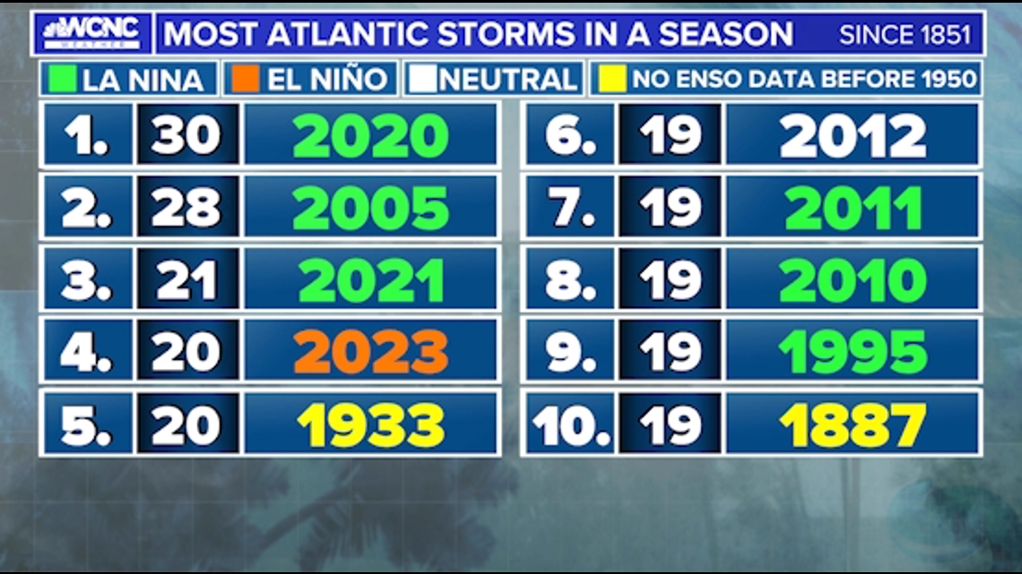
The most active Atlantic hurricane season was in 2020 which had 30 named storms. The hurricane season in 2020 outranked the previous record, set in 2005, by two storms.
Both seasons started off with neutral ENSO phases but ended in a weak-to-moderate La Niña.
The 2005 Atlantic hurricane season was historic alone for Hurricane Katrina but that year also saw the strongest overall storms, according to the Accumulated Cyclone Energy (ACE), which tracks storm strength. The 2005 season produced storms twice the average ACE strength.
Nearly all of the strongest hurricane seasons since 1950 came during either a neutral or La Nina pattern. Only one season came during El Nino.

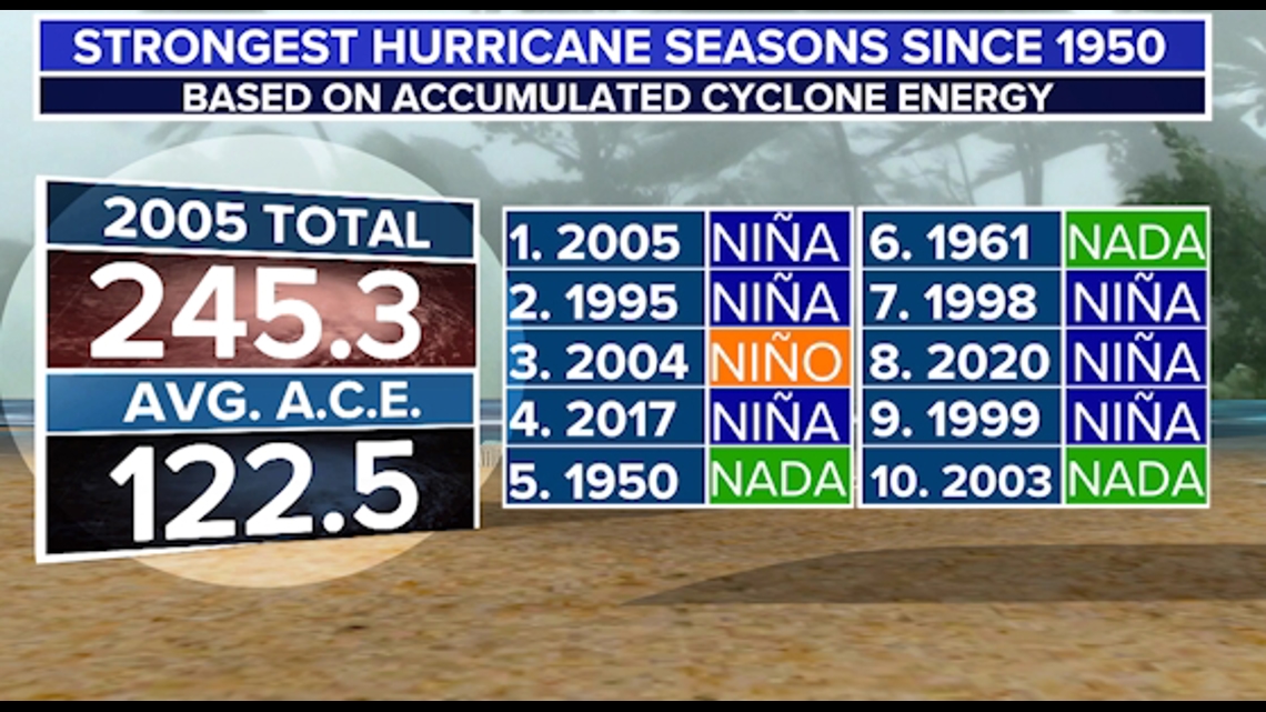
Of the most active Atlantic hurricane seasons, six came during La Niña conditions.

On average, a La Niña phase leads to roughly four more hurricanes than normal.
WCNC Charlotte’s Weather IQ YouTube channel gives detailed explainers from the WCNC Charlotte weather meteorologists to help you learn and understand weather, climate and science. Watch previous stories where you can raise your Weather IQ in the YouTube playlist below and subscribe to get updated when new videos are uploaded.