- Tornado Watch for Coastal Plains Sunday evening
- Two people, including a child, dead after Oklahoma tornadoes; governor declares state of emergency
- Build your hurricane season preparedness kits this tax-free weekend
- Residents begin going through the rubble after tornadoes hammer parts of Nebraska and Iowa
- Midwest tornadoes flatten homes in Nebraska suburbs and leave trails of damage in Iowa
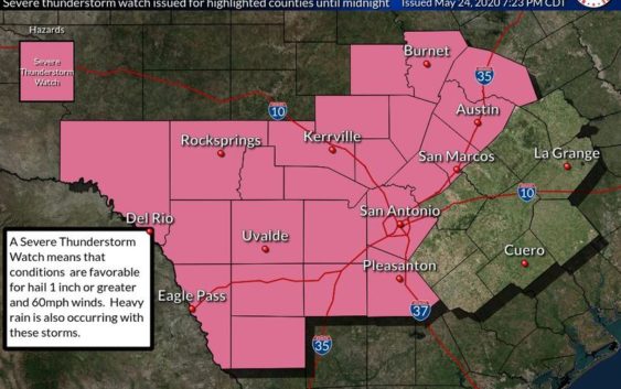
Severe Thunderstorms Hit San Antonio Area
This post was updated on Sunday, May 24, at 10:12 p.m.
Severe thunderstorms are moving through central Texas.
A tornado warning was issued for Comal, Guadalupe and Bexar counties, and more than 40,000 CPS customers lost power, including the far West Side, Helotes, Shavano Park, Leon Springs, Leon Valley, the Medical Center area, south of UTSA, north of the airport and Stone Oak.
More storms are forecast through Tuesday.
Severe thunderstorm watches and warnings and flash flood watches and warnings were posted for some areas of the region after a previous rain on Saturday night had already left the ground saturated.
To our customers & media partners: Our outage map is updating every 15 mins with the latest info.
We have multiple crews on standby & anxiously waiting to serve you. Currently, we have 135 outages affecting 21,077 customers.
Please stay safe!
LATEST: https://t.co/r3wzXYchPo pic.twitter.com/ZlaLjBUYQC
— CPS Energy (@cpsenergy) May 25, 2020
Flash flood warnings were placed in effect for Real, Uvalde, Bandera and Medina Counties to the west of San Antonio after rain up to three inches fell on some spots.
Tornado-warned storm in San Antonio pic.twitter.com/2dWn14VIam
— Uncle Neil (@716SportsGuy) May 25, 2020
Meteorologist Eric Platt of the National Weather Service in New Braunfels saw forecast models earlier in the day.
“We’re expecting a complex of thunderstorms to be moving in from the west, and so the main concern we’re looking at is the possibility of some large hail, damaging winds with this line of thunderstorms and also some heavy rainfall,.” he said.
Welp. Our back yard is flooding. We’re under a flash flood and tornado warning.
Based on radar, any rotation is probably north of us right now. We’re on a gentle grade, so not worried about flooding. But things have been hitting the side of the house. pic.twitter.com/gJV6Q0nDPl
— Off Brand (@OffBrandCosplay) May 25, 2020
Hail the size of ping pong balls and 60-mile an hour winds were reported around Carrizo Springs in Dimmit County.
Half dollar-sized hail was reported northwest of Dilley in Frio County.
Some trees were uprooted and a roof blown off one mile east of Scenic Oaks.
Some tree limbs were downed in the Helotes area and near Evans and Bulverde Roads in northern San Antonio.